- Collections
- Historical Maps of Singapore
Title
Year
Author
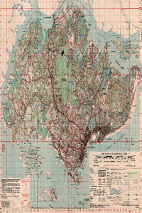
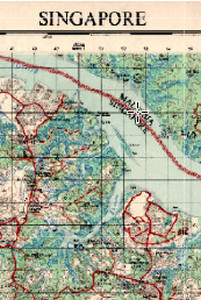
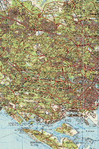
Singapore, 1958 (Scale: 1:63,360)
![]()
Singapore, 1958 (Scale: 1:63,360)
1958
Great Britain. Directorate of Military Survey
Malaya. Survey Department
Metadata
| Collection | Historical Maps of Singapore |
|---|---|
| Author/Creator |
Great Britain. Directorate of Military Survey Malaya. Survey Department |
| Title |
Singapore, 1958 (Scale: 1:63,360) |
| Publication Date | 1958 |
| Publisher | London: D. Survey, War Office and Air Ministry |
| DOI | |
| Subject |
Singapore -- Maps |
| Page | 1 sheet |
| Language | English |
| Content Type | Map |
| Object Type |
Text |
| Terms of Use |
openAccess |
| Terms of Use Others | No reproduction for commercial purposes. See terms of use on libmaps.nus.edu.sg for details. |
| Repository | NUS Libraries |
| Spatial Coverage |
Singapore |
| Version of work | GSGS 4923, Sheet Singapore Edition 1-GSGS |
| Description |
This topographical map shows the entire Singapore with detail on contours, networks of roads and railways, international boundaries, water features, relief, buildings and vegetation. The coastline of Johore along the Straits of Johore is also shown. Map covers the Johore (Johor) Strait, parts of Punggol, Ulu Bedok, Bedok, Changi, Pulau Ubin, Pulau Serangoon and other surrounding islands. It shows Gammon Malaya Quarry, other granite quarries and fisheries reserves in Pulau Ubin, Public Works Department Labourers Lines, Handicapped Childrens’ Home, Maternity and Children’s Welfare Centre and government bungalows in Changi, Ubin Estate, Ong Ting Lye Estate, Wah Hong Estate, Tampines Estate, Bukit Sembawang Estate, Hun Yeang Village, Kampong Noordin, Pasir Ris Village, Kampong Loyang, Yan Kit Village, Changi Village, proposed international airport under construction, residential development areas, cemeteries, industry sites, rural areas, Sungei Serangoon, Sungei Tampines, streams and rivers, existing and proposed community and public utility facilities, roads and other land use.This map was prepared under the direction of the Assistant Director of Survey, Far East Land Forces, surveyed by 84 Field Survey Squadron RE and the Singapore Survey Department, compiled and drawn by S70 Map Reproduction Troop RE and the Singapore Survey Department. It was scanned by Sakinah Yusof, Department of Geography, National University of Singapore (NUS) and georeferenced by Leon Gaw Yan Feng, with kind permission from Singapore Land Authority and Ministry of Defence for NUS Libraries to provide viewing of the map service over the internet. |
Singapore, 1963 (Scale: 1:63,360)
![]()
Singapore, 1963 (Scale: 1:63,360)
Metadata
| Collection | Historical Maps of Singapore |
|---|---|
| Author/Creator |
Great Britain. Directorate of Military Survey |
| Title |
Singapore, 1963 (Scale: 1:63,360) |
| Publication Date | 1963 |
| Publisher | London: Directorate of Military Survey |
| DOI | |
| Subject |
Singapore -- Maps |
| Page | 1 sheet |
| Language | English |
| Content Type | Map |
| Object Type |
Text |
| Terms of Use |
openAccess |
| Terms of Use Others | No reproduction for commercial purposes. See terms of use on libmaps.nus.edu.sg for details. |
| Repository | NUS Libraries |
| Spatial Coverage |
Singapore |
| Version of work | GSGS 4923, Sheet Singapore Edition 2-GSGS |
| Description |
This topographical map covers the Johore (Johor) Strait, parts of Punggol, Ulu Bedok, Bedok, Changi, Pulau Ubin, Pulau Serangoon and other surrounding islands. It shows Gammon Malaya Quarry, other granite quarries and fisheries reserves in Pulau Ubin, Public Works Department Labourers Lines, Handicapped Childrens' Home, Maternity and Children's Welfare Centre and government bungalows in Changi, Ubin Estate, Ong Ting Lye Estate, Wah Hong Estate, Tampines Estate, Bukit Sembawang Estate, Hun Yeang Village, Kampong Noordin, Pasir Ris Village, Kampong Loyang, Yan Kit Village, Changi Village, proposed international airport under construction, residential development areas, cemeteries, industry sites, rural areas, Sungei Serangoon, Sungei Tampines, streams and rivers, existing and proposed community and public utility facilities, roads and other land use.This map was prepared under the direction of the Assistant Director of Survey, Far East Land Forces, surveyed by 84 Field Survey Squadron RE and the Singapore Survey Department, compiled and drawn by S70 Map Reproduction Troop RE and the Singapore Survey Department. It was scanned by Sakinah Yusof, Department of Geography, National University of Singapore (NUS) and georeferenced by Leon Gaw Yan Feng, with kind permission from Singapore Land Authority and Ministry of Defence for NUS Libraries to provide viewing of the map service over the internet. |
Singapore, 1969 (Scale: 1:63,360)
![]()
Singapore, 1969 (Scale: 1:63,360)
Metadata
| Collection | Historical Maps of Singapore |
|---|---|
| Author/Creator |
Singapore. Survey Department. |
| Title |
Singapore, 1969 (Scale: 1:63,360) |
| Publication Date | 1969 |
| Publisher | Singapore: Survey Department |
| DOI | |
| Subject |
Singapore -- Maps |
| Page | 1 sheet |
| Language | English |
| Content Type | Map |
| Object Type |
Text |
| Terms of Use |
openAccess |
| Terms of Use Others | No reproduction for commercial purposes. See terms of use on libmaps.nus.edu.sg for details. |
| Repository | NUS Libraries |
| Spatial Coverage |
Singapore |
| Version of work | Singapore Series 1 Edition 1 |
| Description |
Topographical map of Singapore. This map was published by Chief Surveyor, Singapore, prepared under the direction of the Assistant Director of Survey, Far East Land Forces, by 84 Field Survey Squadron RE, scanned by Sakinah Yusof, Department of Geography, National University of Singapore (NUS), and georeferenced by Leon Gaw Yan Feng, with kind permission from Singapore Land Authority and Ministry of Defence for NUS Libraries to provide viewing of the map service over the internet. |
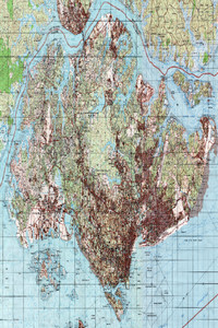
Singapore, 1971 (Scale: 1:63,360)
![]()
Singapore, 1971 (Scale: 1:63,360)
Metadata
| Collection | Historical Maps of Singapore |
|---|---|
| Author/Creator |
Singapore. Ministry of Defence. Mapping Unit |
| Title |
Singapore, 1971 (Scale: 1:63,360) |
| Publication Date | 1971 |
| Publisher | Singapore: Mapping Unit, Ministry of Defence |
| DOI | |
| Subject |
Singapore -- Maps |
| Page | 1 sheet |
| Language | English |
| Content Type | Map |
| Object Type |
Text |
| Terms of Use |
openAccess |
| Terms of Use Others | No reproduction for commercial purposes. See terms of use on libmaps.nus.edu.sg for details. |
| Repository | NUS Libraries |
| Spatial Coverage |
Singapore |
| Version of work | TOPO 1 Sheet Singapore Edition 1-SMU |
| Description |
This topographical map shows the entire Singapore with detail on networks of roads and railways, international boundaries, water features, relief, buildings and vegetation. It also covers Jurong, Pandan, Pasir Panjang, Telok Blanga (Blangah), Toa Payoh, South Seletar, Mandai, Kranji, Bukit Timah and Tanglin. It shows Huat Hong Village, Bukit Panjang Village, Bukit Timah Village, Pasir Panjang Village, Holland Village, Chasseriau Estate I and II, Kilburn Estate, National Carbon and Central Refinery in Princess Elizabeth Estate, Princess Margaret Estate, granite quarries including Gammon Granite Quarry, Singapore Granite Quarries, Hindhede Qaurry, Public Works Department Quarry, Nanyang Shoes Factory, Chua Guan Hong Rubber Factory and Hock Thong Rubber Factory in Jurong, Lam Soon Cannery Factory, sewerage disposal site in Pandan, Peirce Reservoir, MacRitchie Reservoir, Pandan Nature Reserve, catchment areas, Bukit Batok, Bukit Tinggi, Mount Echo, Proposed new planning of roads, railway line, rivers, existing and proposed community and public utility facilities and others. The coastline of Johor along the Straits of Johor is also shown.This map was produced by the Mapping Unit, Ministry of Defence, Singapore, scanned by Sakinah Yusof, Department of Geography, National University of Singapore (NUS), and georeferenced by Leon Gaw Yan Feng, with kind permission from Singapore Land Authority and Ministry of Defence for NUS Libraries to provide viewing of the map service over the internet. |
Singapore, 1974 (Scale: 1:50,000)
![]()
Singapore, 1974 (Scale: 1:50,000)
Metadata
| Collection | Historical Maps of Singapore |
|---|---|
| Author/Creator |
Singapore. Ministry of Defence. Mapping Unit |
| Title |
Singapore, 1974 (Scale: 1:50,000) |
| Publication Date | 1974 |
| Publisher | Singapore: Mapping Unit, Ministry of Defence |
| DOI | |
| Subject |
Singapore -- Maps |
| Page | 2 sheets |
| Language | English |
| Content Type | Map |
| Object Type |
Text |
| Terms of Use |
openAccess |
| Terms of Use Others | No reproduction for commercial purposes. See terms of use on libmaps.nus.edu.sg for details. |
| Repository | NUS Libraries |
| Spatial Coverage |
Singapore |
| Version of work | SMU 075 Edition 1 SMU |
| Description |
A mosaic of 2 sheets of topographical maps of Singapore:Sheet 1 (Singapore West): This map shows Singapore with detail on networks of roads and railways, international boundaries, water features, relief, buildings and vegetation. The coastline of Johor along the Straits of Johor is also shown.Sheet 2 (Singapore East): This map shows Eastern Singapore with detail on networks of roads and railways, international boundaries, water features, relief, buildings and vegetation. The coastline of Johor along the Straits of Johor is also shown.This map was produced by the Mapping Unit, Ministry of Defence, Singapore, scanned by Sakinah Yusof, Department of Geography, National University of Singapore (NUS), georeferenced by Leon Gaw Yan Feng and mosaicked by NUS Libraries, with kind permission from Singapore Land Authority and Ministry of Defence for NUS Libraries to provide viewing of the map service over the internet. |
Singapore, 1974 (Scale: 1:75,000)
![]()
Singapore, 1974 (Scale: 1:75,000)
Metadata
| Collection | Historical Maps of Singapore |
|---|---|
| Author/Creator |
Singapore. Ministry of Defence. Mapping Unit |
| Title |
Singapore, 1974 (Scale: 1:75,000) |
| Publication Date | 1974 |
| Publisher | Singapore: Mapping Unit, Ministry of Defence |
| DOI | |
| Subject |
Singapore -- Maps |
| Page | 2 sheets |
| Language | English |
| Content Type | Map |
| Object Type |
Text |
| Terms of Use |
openAccess |
| Terms of Use Others | No reproduction for commercial purposes. See terms of use on libmaps.nus.edu.sg for details. |
| Repository | NUS Libraries |
| Spatial Coverage |
Singapore |
| Version of work | SMU 075 Edition 1 SMU |
| Description |
A mosaic of 2 sheets of topographical maps of Singapore:Sheet 1 (Singapore West): This map shows Singapore with detail on networks of roads and railways, international boundaries, water features, relief, buildings and vegetation. The coastline of Johor along the Straits of Johor is also shown.Sheet 2 (Singapore East): This map shows Eastern Singapore with detail on networks of roads and railways, international boundaries, water features, relief, buildings and vegetation. The coastline of Johor along the Straits of Johor is also shown.This map was produced by the Mapping Unit, Ministry of Defence, Singapore, scanned by Sakinah Yusof, Department of Geography, National University of Singapore (NUS), georeferenced by Leon Gaw Yan Feng and mosaicked by NUS Libraries, with kind permission from Singapore Land Authority and Ministry of Defence for NUS Libraries to provide viewing of the map service over the internet. |
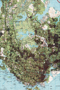
Singapore, 1978 (Scale: 1:50,000)
![]()
Singapore, 1978 (Scale: 1:50,000)
Metadata
| Collection | Historical Maps of Singapore |
|---|---|
| Author/Creator |
Singapore. Ministry of Defence. Mapping Unit |
| Title |
Singapore, 1978 (Scale: 1:50,000) |
| Publication Date | 1978 |
| Publisher | Singapore: Mapping Unit, Ministry of Defence |
| DOI | |
| Subject |
Singapore -- Maps |
| Page | 1 sheet |
| Language | English |
| Content Type | Map |
| Object Type |
Text |
| Terms of Use |
openAccess |
| Terms of Use Others | No reproduction for commercial purposes. See terms of use on libmaps.nus.edu.sg for details. |
| Repository | NUS Libraries |
| Spatial Coverage |
Singapore |
| Version of work | SMU 075 Edition 2 |
| Description |
This map shows Singapore with detail on networks of roads and railways, international boundaries, water features, relief, buildings and vegetation. The coastline of Johor along the Straits of Johor is also shown.This map was produced by the Mapping Unit, Ministry of Defence, Singapore, scanned by Sakinah Yusof, Department of Geography, National University of Singapore (NUS), and georeferenced by Leon Gaw Yan Feng, with kind permission from Singapore Land Authority and Ministry of Defence for NUS Libraries to provide viewing of the map service over the internet. |
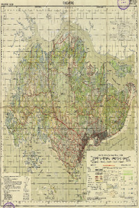
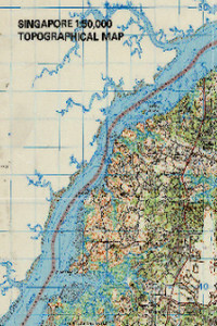
Singapore, 1983 (Scale: 1:50,000)
![]()
Singapore, 1983 (Scale: 1:50,000)
Metadata
| Collection | Historical Maps of Singapore |
|---|---|
| Author/Creator |
Singapore. Ministry of Defence. Mapping Unit |
| Title |
Singapore, 1983 (Scale: 1:50,000) |
| Publication Date | 1983 |
| Publisher | Singapore: Mapping Unit, Ministry of Defence |
| DOI | |
| Subject |
Singapore -- Maps |
| Page | 1 sheet |
| Language | English |
| Content Type | Map |
| Object Type |
Text |
| Terms of Use |
openAccess |
| Terms of Use Others | No reproduction for commercial purposes. See terms of use on libmaps.nus.edu.sg for details. |
| Repository | NUS Libraries |
| Spatial Coverage |
Singapore |
| Version of work | SMU 075 Edition 3 |
| Description |
This map shows the entire Singapore with detail on networks of roads and railways, international boundaries, water features, relief, buildings and vegetation. The coastline of Johore along the Straits of Johore is also shown.Central Region: Bishan, Bukit Merah, Bukit Timah, Novena, Potong Pasir, Queenstown, Tanglin, Tiong Bahru, Toa Payoh, Southern Islands, Bras Basah, Chinatown, Downtown Core, Marina Bay, Marina Centre, Marina East, Marina South, Newton, Orchard, Outram, Raffles Place, River Valley, Rochor, Tanjong Pagar.East Region: Bedok, Changi, Changi Bay, Changi East, Changi Village, Geylang, Kallang, Kallang Bahru, Katong, Marine Parade, Paya Lebar, Pasir Ris, Siglap, Tampines, Tampines North, Ubi.North Region: Central Water Catchment, Lim Chu Kang, Mandai, Sembawang, Simpang, Sungei Kadut, Woodlands, Yishun.North-East Region: Ang Mo Kio, Hougang, North-eastern Islands, Punggol, Seletar, Sengkang, Senoko, Serangoon, Serangoon Gardens, Serangoon North.West Region: Bukit Batok, Bukit Panjang, Boon Lay, Bulim, Choa, Chu Kang, Clementi, Joo Koon, Jurong East, Jurong West, Tengah, Tuas, Tuas South, Western Islands, Western Water CatchmentThis map was produced by the Mapping Unit, Ministry of Defence, Singapore, scanned by Sakinah Yusof, Department of Geography, National University of Singapore (NUS), and georeferenced by Leon Gaw Yan Feng, with kind permission from Singapore Land Authority and Ministry of Defence for NUS Libraries to provide viewing of the map service over the internet. |
Singapore, 1987 (Scale: 1:50,000)
![]()
Singapore, 1987 (Scale: 1:50,000)
Metadata
| Collection | Historical Maps of Singapore |
|---|---|
| Author/Creator |
Singapore. Ministry of Defence. Mapping Unit |
| Title |
Singapore, 1987 (Scale: 1:50,000) |
| Publication Date | 1987 |
| Publisher | Singapore: Mapping Unit, Ministry of Defence |
| DOI | |
| Subject |
Singapore -- Maps |
| Page | 1 sheet |
| Language | English |
| Content Type | Map |
| Object Type |
Text |
| Terms of Use |
openAccess |
| Terms of Use Others | No reproduction for commercial purposes. See terms of use on libmaps.nus.edu.sg for details. |
| Repository | NUS Libraries |
| Spatial Coverage |
Singapore |
| Version of work | SMU 075 Edition 4 |
| Description |
This map shows Singapore with detail on networks of roads and railways, international boundaries, water features, relief, buildings and vegetation. The coastline of Johor along the Straits of Johor is also shown.Central Region: Bishan, Bukit Merah, Bukit Timah, Novena, Potong Pasir, Queenstown, Tanglin, Tiong Bahru, Toa Payoh, Southern Islands, Bras Basah, Chinatown, Downtown Core, Marina Bay, Marina Centre, Marina East, Marina South, Newton, Orchard, Outram, Raffles Place, River Valley, Rochor, Tanjong Pagar.East Region: Bedok, Changi, Changi Bay, Changi East, Changi Village, Geylang, Kallang, Kallang Bahru, Katong, Marine Parade, Paya Lebar, Pasir Ris, Siglap, Tampines, Tampines North, Ubi.North Region: Central Water Catchment, Lim Chu Kang, Mandai, Sembawang, Simpang, Sungei Kadut, Woodlands, Yishun. North-East Region: Ang Mo Kio, Hougang, North-eastern Islands, Punggol, Seletar, Sengkang, Senoko, Serangoon, Serangoon Gardens, Serangoon North.West Region: Bukit Batok, Bukit Panjang, Boon Lay, Bulim, Choa, Chu Kang, Clementi, Joo Koon, Jurong East, Jurong West, Tengah, Tuas, Tuas South, Western Islands, Western Water CatchmentThis map was produced by the Mapping Unit, Ministry of Defence, Singapore, scanned by Sakinah Yusof, Department of Geography, National University of Singapore (NUS), and georeferenced by Leon Gaw Yan Feng, with kind permission from Singapore Land Authority and Ministry of Defence for NUS Libraries to provide viewing of the map service over the internet. |
Singapore, 1993 (Scale: 1:50,000)
![]()
Singapore, 1993 (Scale: 1:50,000)
Metadata
| Collection | Historical Maps of Singapore |
|---|---|
| Author/Creator |
Singapore. Ministry of Defence. Mapping Unit |
| Title |
Singapore, 1993 (Scale: 1:50,000) |
| Publication Date | 1993 |
| Publisher | Singapore: Mapping Unit, Ministry of Defence |
| DOI | |
| Subject |
Singapore -- Maps |
| Page | 1 sheet |
| Language | English |
| Content Type | Map |
| Object Type |
Text |
| Terms of Use |
openAccess |
| Terms of Use Others | No reproduction for commercial purposes. See terms of use on libmaps.nus.edu.sg for details. |
| Repository | NUS Libraries |
| Spatial Coverage |
Singapore |
| Version of work | SMU 075 Edition 5 |
| Description |
This map shows Singapore with detail on networks of roads and railways, international boundaries, water features, relief, buildings and vegetation. The coastline of Johor along the Straits of Johor is also shown.Central Region: Bishan, Bukit Merah, Bukit Timah, Novena, Potong Pasir, Queenstown, Tanglin, Tiong Bahru, Toa Payoh, Southern Islands, Bras Basah, Chinatown, Downtown Core, Marina Bay, Marina Centre, Marina East, Marina South, Newton, Orchard, Outram, Raffles Place, River Valley, Rochor, Tanjong Pagar.East Region: Bedok, Changi, Changi Bay, Changi East, Changi Village, Geylang, Kallang, Kallang Bahru, Katong, Marine Parade, Paya Lebar, Pasir Ris, Siglap, Tampines, Tampines North, UbiNorth Region: Central Water Catchment, Lim Chu Kang, Mandai, Sembawang, Simpang, Sungei Kadut, Woodlands, Yishun.North-East Region: Ang Mo Kio, Hougang, North-eastern Islands, Punggol, Seletar, Sengkang, Senoko, Serangoon, Serangoon Gardens, Serangoon North.West Region: Bukit Batok, Bukit Panjang, Boon Lay, Bulim, Choa, Chu Kang, Clementi, Joo Koon, Jurong East, Jurong West, Tengah, Tuas, Tuas South, Western Islands, Western Water CatchmentThis map was produced by the Mapping Unit, Ministry of Defence, Singapore, scanned by Sakinah Yusof, Department of Geography, National University of Singapore (NUS), and georeferenced by Leon Gaw Yan Feng, with kind permission from Singapore Land Authority and Ministry of Defence for NUS Libraries to provide viewing of the map service over the internet. |
Loading more items please wait...
All items are loaded.
Error loading more items. Please reload the page an try again.