- Collections
- Historical Maps of Singapore
Title
Year
Author
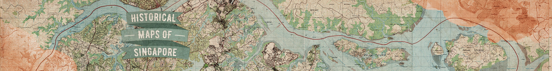
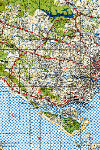
Land use survey of rural Singapore. Sheet 74 (Scale 1:6,336)
![]()
Land use survey of rural Singapore. Sheet 74 (Scale 1:6,336)
1958
University of Malaya in Kuala Lumpur. Department of Geography
University of Malaya (Singapore)
Singapore. Planning Dept
Asia Foundation
Metadata
| Collection | Historical Maps of Singapore |
|---|---|
| Author/Creator |
University of Malaya in Kuala Lumpur. Department of Geography University of Malaya (Singapore) Singapore. Planning Dept Asia Foundation |
| Title |
Land use survey of rural Singapore. Sheet 74 (Scale 1:6,336) |
| Publication Date | 1958 |
| Publisher | Kuala Lumpur: Department of Geography, University of Malaya in Kuala Lumpur |
| DOI | |
| Call Number | G8041.G4 Uni |
| Subject |
Agriculture -- Singapore -- Maps Land use -- Singapore -- Maps Phytogeography -- Singapore -- Maps |
| Page | 1 sheet |
| Language | English |
| Content Type | Map |
| Object Type |
Text |
| Terms of Use |
openAccess |
| Terms of Use Others | No reproduction for commercial purposes. See terms of use on libmaps.nus.edu.sg for details. |
| Repository | NUS Libraries |
| Spatial Coverage |
Singapore |
| Description |
Land use map series of Singapore showing transportation, water features, vegetation, cultivation, farming, industry and buildings. Each sheet has individual numbers. |
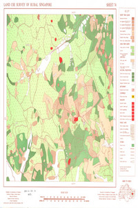
Land use survey of rural Singapore. Sheet 8 (Scale 1:6,336)
![]()
Land use survey of rural Singapore. Sheet 8 (Scale 1:6,336)
1958
University of Malaya in Kuala Lumpur. Department of Geography
University of Malaya (Singapore)
Singapore. Planning Dept
Asia Foundation
Metadata
| Collection | Historical Maps of Singapore |
|---|---|
| Author/Creator |
University of Malaya in Kuala Lumpur. Department of Geography University of Malaya (Singapore) Singapore. Planning Dept Asia Foundation |
| Title |
Land use survey of rural Singapore. Sheet 8 (Scale 1:6,336) |
| Publication Date | 1958 |
| Publisher | Kuala Lumpur: Department of Geography, University of Malaya in Kuala Lumpur |
| DOI | |
| Call Number | G8041.G4 Uni |
| Subject |
Agriculture -- Singapore -- Maps Land use -- Singapore -- Maps Phytogeography -- Singapore -- Maps |
| Page | 1 sheet |
| Language | English |
| Content Type | Map |
| Object Type |
Text |
| Terms of Use |
openAccess |
| Terms of Use Others | No reproduction for commercial purposes. See terms of use on libmaps.nus.edu.sg for details. |
| Repository | NUS Libraries |
| Spatial Coverage |
Singapore |
| Description |
Land use map series of Singapore showing transportation, water features, vegetation, cultivation, farming, industry and buildings. Each sheet has individual numbers. |
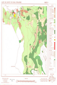
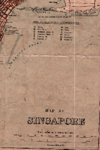
Map of Business Area Singapore, 1932 (Scale 1:6,336)
![]()
Map of Business Area Singapore, 1932 (Scale 1:6,336)
Metadata
| Collection | Historical Maps of Singapore |
|---|---|
| Author/Creator |
Malaya. Survey Department |
| Title |
Map of Business Area Singapore, 1932 (Scale 1:6,336) |
| Publication Date | 1932 |
| Publisher | Singapore: Federated Malay States Survey Department |
| DOI | |
| Subject |
Singapore -- Maps |
| Page | 1 sheet |
| Language | English |
| Content Type | Map |
| Object Type |
Text |
| Terms of Use |
openAccess |
| Terms of Use Others | Enlarged version of the map is available online: https://libmaps.nus.edu.sg. |
| Repository | NUS Libraries |
| Spatial Coverage |
Singapore |
| Description |
This map shows the business area of Singapore with detail of roads railways, buildings and water bodies. Major features and areas shown in this map include Tanjong Pagar, Orchard Road, Race Course, Bukit Timah Road, Rochor Canal, Singapore River, Monk’s Hill and Fort Canning. An inset of Keppel Hill is also shown.This map was produced by the Federated Malay States Survey Department, scanned by Sakinah Yusof, Department of Geography, National University of Singapore, and georeferenced by Low Taoyang Isaac and Leon Gaw Yan Feng. |
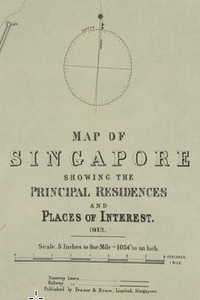
Map of Singapore Showing the Principal Residences and Places of Interest, 1913 (Scale 1:12,672)
![]()
Map of Singapore Showing the Principal Residences and Places of Interest, 1913 (Scale 1:12,672)
1913
Metadata
| Collection | Historical Maps of Singapore |
|---|---|
| Title |
Map of Singapore Showing the Principal Residences and Places of Interest, 1913 (Scale 1:12,672) |
| Publication Date | 1913 |
| Publisher | Singapore: Fraser and Neave Limited |
| DOI | |
| Subject |
Singapore -- Maps |
| Page | 1 sheet |
| Language | English |
| Content Type | Map |
| Object Type |
Text |
| Terms of Use |
openAccess |
| Terms of Use Others | Enlarged version of the map is available online: https://libmaps.nus.edu.sg. |
| Repository | NUS Libraries |
| Spatial Coverage |
Singapore |
| Description |
This map shows roads, railway line, buildings in residential and commercial areas, public buildings in Singapore town centre, Chinese villages, Chinese burial grounds, docks, wharves, mangrove swamp areas, Cluny Road Railway Station, Singapore River, Kalang River, Rochor River, Keppel Harbour, Kampong Rokok, Kampong Laut, Kampong Bugis, Kampong Boyan, Kampong Saigon, Bukit Tunggul, Mount Victoria, Mount Alma, Pearls Hill, Mount Faber, Botanical Gardens, Tanglin Barracks, General Hospital, and others Southern Singapore with detail of road networks, buildings, water bodies, islands and major districts of Singapore.This map was scanned by Sakinah Yusof, Department of Geography, National University of Singapore, and georeferenced by Low Taoyang Isaac. |
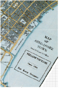
Map of Singapore Town, 1932 (Scale 1:6,336)
![]()
Map of Singapore Town, 1932 (Scale 1:6,336)
Metadata
| Collection | Historical Maps of Singapore |
|---|---|
| Title |
Map of Singapore Town, 1932 (Scale 1:6,336) |
| Publication Date | 1932 |
| Publisher | Kuala Lumpur: Surveyor-General, Federated Malay States (F.M.S.), Central Survey Office |
| DOI | |
| Subject |
Singapore -- Maps |
| Page | 1 sheet |
| Language | English |
| Content Type | Map |
| Object Type |
Text |
| Terms of Use |
openAccess |
| Terms of Use Others | Enlarged version of the map is available online: https://libmaps.nus.edu.sg. |
| Repository | NUS Libraries |
| Spatial Coverage |
Singapore |
| Description |
Map of Singapore town published in 193?.The map producer was not given. The map was scanned by Sakinah Yusof, Department of Geography, National University of Singapore, and georeferenced by Low Taoyang Isaac. |
Map of Singapore, 1914 (Scale 1:31,680)
![]()
Map of Singapore, 1914 (Scale 1:31,680)
Metadata
| Collection | Historical Maps of Singapore |
|---|---|
| Title |
Map of Singapore, 1914 (Scale 1:31,680) |
| Publication Date | 1914 |
| Publisher | London: War Office |
| DOI | |
| Subject |
Singapore -- Maps |
| Page | 1 sheet |
| Language | English |
| Content Type | Map |
| Object Type |
Text |
| Terms of Use |
openAccess |
| Terms of Use Others | Enlarged version of the map is available online: https://libmaps.nus.edu.sg. |
| Repository | NUS Libraries |
| Spatial Coverage |
Singapore |
| Description |
This map shows southern Singapore with detail on networks of roads, relief, water features and buildings. Name of hills and their contours are shown in the map. Major features include Pasir Panjang Ridges, Kalang Reservoir, Catchment Area, plantations, Bukit Timah Road, Balestier Plain, Tanjong Rhu, Pulau Blakan Mati, Pulau Brani, Pulau Hantu and Singapore City.This map was produced by the Geographical Section, General Staff, scanned by Sakinah Yusof, Department of Geography, National University of Singapore, and georeferenced by Low Taoyang Isaac. |
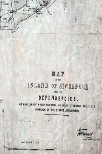
Map of the Island of Singapore and its Dependencies, 1862 (Scale 1:63,360)
![]()
Map of the Island of Singapore and its Dependencies, 1862 (Scale 1:63,360)
Metadata
| Collection | Historical Maps of Singapore |
|---|---|
| Author/Creator |
Khan, Wahid |
| Title |
Map of the Island of Singapore and its Dependencies, 1862 (Scale 1:63,360) |
| Publication Date | 1873 |
| Publisher | London: Edward Stanford Lithographer |
| DOI | |
| Subject |
Islands -- Singapore -- Maps Singapore -- Maps |
| Page | 1 sheet |
| Language | English |
| Content Type | Map |
| Object Type |
Text |
| Terms of Use |
openAccess |
| Terms of Use Others | Enlarged version of the map is available online: https://libmaps.nus.edu.sg |
| Repository | NUS Libraries |
| Spatial Coverage |
Singapore |
| Description |
This map shows Singapore with detail on networks of roads, water features, villages, surrounding islands and boundaries of the various districts. The coastline of Territory of Johore along the Old Straits or Silat Tambrau is also shown.This map was produced by the Surveyor General of the Straits Settlements, scanned by Sakinah Yusof, Department of Geography, National University of Singapore, and georeferenced by Richard Ho. |
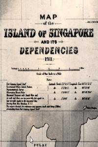
Map of the Island of Singapore and its Dependencies, 1911 (Scale 1:63,360)
![]()
Map of the Island of Singapore and its Dependencies, 1911 (Scale 1:63,360)
Metadata
| Collection | Historical Maps of Singapore |
|---|---|
| Title |
Map of the Island of Singapore and its Dependencies, 1911 (Scale 1:63,360) |
| Publication Date | 1911 |
| Publisher | London: War Office (Geographical Section, General Staff) |
| DOI | |
| Subject |
Islands -- Singapore -- Maps Singapore -- Maps |
| Page | 1 sheet |
| Language | English |
| Content Type | Map |
| Object Type |
Text |
| Terms of Use |
openAccess |
| Terms of Use Others | Enlarged version of the map is available online: https://libmaps.nus.edu.sg. |
| Repository | NUS Libraries |
| Spatial Coverage |
Singapore |
| Description |
This map shows Singapore with detail on networks of roads, water features, surrounding islands and boundaries of the various districts. The coastline of Territory of Johore along the Old Strait or Silat Tembrau is also shown.This map was scanned by Sakinah Yusof, Department of Geography, National University of Singapore, and georeferenced by Leon Gaw Yan Feng. |
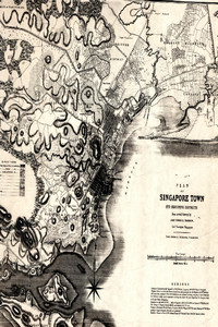
Plan of Singapore Town and Adjoining Districts from actual survey, 1846 by John Turnbull Thomson, Government Surveyor, Singapore
![]()
Plan of Singapore Town and Adjoining Districts from actual survey, 1846 by John Turnbull Thomson, Government Surveyor, Singapore
1846
Thomson, John Turnbull , 1821-1884.
Metadata
| Collection | Historical Maps of Singapore |
|---|---|
| Author/Creator |
Thomson, John Turnbull , 1821-1884. |
| Title |
Plan of Singapore Town and Adjoining Districts from actual survey, 1846 by John Turnbull Thomson, Government Surveyor, Singapore |
| Publication Date | 1846 |
| Publisher | London: J. M. Richardson |
| DOI | |
| Subject |
Singapore -- Maps |
| Page | 1 sheet |
| Language | English |
| Content Type | Map |
| Object Type |
Text |
| Terms of Use |
openAccess |
| Terms of Use Others | Enlarged version of the map is available online: https://libmaps.nus.edu.sg |
| Repository | NUS Libraries |
| Spatial Coverage |
Singapore |
| Description |
This map shows the demarcation and development of Singapore town and land use of its adjoining districts. This is the most detailed map of Singapore’s town of the time that is known. This map includes Singapore Town, Downtown, Chinatown, Little India, Malay Village, Raffles Place, Orchard, Tiong Bahru, Keppel Road, Telok Ayer, Bras Basah, Kallang, Tanah Merah, Singapore Harbour. This map was scanned by Sakinah Yusof, Department of Geography, National University of Singapore, and georeferenced by Leon Gaw Yan Feng. |
Singapore & Johor Bahru, 1945 (Scale: 1:63,360)
![]()
Singapore & Johor Bahru, 1945 (Scale: 1:63,360)
Metadata
| Collection | Historical Maps of Singapore |
|---|---|
| Title |
Singapore & Johor Bahru, 1945 (Scale: 1:63,360) |
| Publication Date | 1945 |
| Publisher | India: Survey Production Centre, Allied Land Forces South East Asia. |
| DOI | |
| Subject |
Singapore -- Maps |
| Page | 1 sheet |
| Language | English |
| Content Type | Map |
| Object Type |
Text |
| Terms of Use |
openAccess |
| Terms of Use Others | Enlarged version of the map is available online: https://libmaps.nus.edu.sg. |
| Repository | NUS Libraries |
| Spatial Coverage |
Singapore |
| Version of work | EditHIND 1035, Sheet 3L/12 4 Editionion 4 |
| Description |
This topographical map shows the entire Singapore and its surrounding islands with detail on contours, roads, land cover type, international boundaries, water features, relief, buildings and vegetation. The coastline of Johore along the Straits of Johore is also shown. 7 Indian Air Survey Company and 110 Map Production Company RE 1945. Singapore & Johore Bahru, 1:63,360. HIND 1035, Sheet 3L/12, 4th Edition. This map was scanned by Sakinah Yusof, Department of Geography, National University of Singapore, and georeferenced by Leon Gaw Yan Feng. |
Loading more items please wait...
All items are loaded.
Error loading more items. Please reload the page an try again.