- Collections
- Historical Maps of Singapore
Title
Year
Author
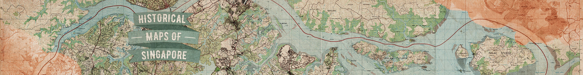
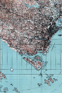
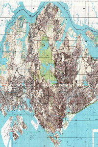
Singapore & Johor, 1966 (Scale 1:25,000)
![]()
Singapore & Johor, 1966 (Scale 1:25,000)
Metadata
| Collection | Historical Maps of Singapore |
|---|---|
| Author/Creator |
Malaya. Survey Department. |
| Title |
Singapore & Johor, 1966 (Scale 1:25,000) |
| Publication Date | 1966 |
| Publisher | Kuala Lumpur: Director of National Mapping, Malaysia, on behalf of the Chief Surveyor, Singapore |
| DOI | |
| Subject |
Singapore -- Maps |
| Page | 7 sheets |
| Language | English |
| Content Type | Map |
| Object Type |
Text |
| Terms of Use |
openAccess |
| Terms of Use Others | No reproduction for commercial purposes. See terms of use on libmaps.nus.edu.sg for details. |
| Repository | NUS Libraries |
| Spatial Coverage |
Singapore |
| Version of work | L802 Sheet 4 Edition 1-DNMM |
| Description |
A mosaic of 7 sheets of topographical maps of Singapore:Sheet 1 (Ama Keng): This map shows the northwestern region of Singapore and the coastline along Straits of Johore, with the state boundary included. Major regions and features in the map include Ama Keng, Lim Chu Kang Road, Kranji Reservoir, Sungei Poyan, Sungei Berih, Sungei Karang, Sungei Kangkar, Sungei Buloh, Sungei Kranji, Sungei Peng Siang, Sarimbun in Singapore and Pelentong, Sungei Sekudai, Sungei Pendas, Sungei Perepat, Sungei Danga, Sungei Melayu in Johore Bahru.Sheet 2 (Nee Soon): The map shows the Northern region of Singapore, with the Singapore and Johore coastline along the Straits of Johore, together with the state boundary. Major features include Woodlands, Sembawang, Kranji, Yio Chu Kang, Nee Soon, Yew Tee, Chong Pang, Marsiling, Sungei Seletar, Mandai, Public Utilities Board Catchment Area, Pulau Seletar, Yio Chu Kang, Serangoon, Johore, and the Causeway Bridge.Sheet 3 (Changi): This map shows the northeast region of Singapore, its coastline along the Straits of Johore, Pulau Ubin, Pulau Sekudu, Pulau Ketam, Pulau Serangoon (Coney Island) and surrounding islands. Johore and its coastline is shown in the map as well. Major regions and features in the map include Changi, Loyang, Pasir Ris, Serangoon, Punggol, Jalan Kayu and Sembawang of mainland Singapore, Sungei Tiram and various estates of Johore Bahru.Sheet 4 (Pulau Tekong): This map shows the island of Pulau Tekong and its surrounding islands that lies northeast to mainland Singapore. The coastline and features of Johore and Pulau Tekong are shown in this map, along with major waterways of the Straits of Johore, Johore River and the state boundary. Major topographical features of Johore are shown in the map, including regions such as Kota Tinggi.Sheet 5 (Jurong): The map shows the south-western region of Singapore. The south-western coastline of Singapore is shown in this map, with the major waterways of Selat Johore, Selat Sembilan and Selat Pandan shown. Major islands displayed in the map include Pulau Sakra, Pulau Bakau, Pulau Ayer Merbau, Pulau Ayer Chawan, Pulau Seraya, Pulau Merlimau, Pulau Pesek, Pulau Mesemut Laut, Pulau Mesemut Darat, Pulau Meskol, Pulau Seburus Dalam, Pulau Seburus Luar Pulau Damar Laut and amongst other smaller islands. Major features and regions displayed in this map include Jurong Industrial Estate, Upper Jurong Road, Tuas, Lokyang, Hong Kah, Kampong Ulu Pandan, Pandan Nature Reserve and Choa Chu Kang.Sheet 6 (Singapore City): The map shows the southern-central region of Singapore. The southern coastline of Singapore is shown, along with islands such as Pulau Blakang Mati, Pulau Hantu, Pulau Bukum and Pulau Brani. Waterways shown include Keppel Harbour and Selat Sengkir, Kallang River, Singapore River, Sungei Pandan. Major regions in the map include Singapore City, Thomson, Ang Mo Kio, Toa Payoh, Potong Pasir, Bukit Timah, Bukit Panjang, Pierce Reservoir, Clementi, Alexandra, Kent Ridge, Jurong, Queenstown and Bukit Gombak.Sheet 7 (Siglap): The map shows the south-eastern region of Singapore in 1966. The south-eastern coast line of Singapore fronting the Straits of Singapore is shown as well. Major regions and features in the map include Kallang, Geylang, Geylang River, Singapore Airport, Simpang Bedok, Chai Chee, Eunos, Kg. Ubi, Kembangan, Opera Estate, Somapah Changi, Sembawang Estate, Tampines Estate, Ho Tong Jen Estate, Pasir Ris, Frankel Estate, East Coast, Siglap, Katong, Tg Katong, Meyer Road, Mountbatten Road, Kg Amber, Marine Parade, Paya Lebar, Tai Seng, Kembangan, Somapah Serangoon and Tanah Merah.The maps were produced by the Chief Surveyor, National Mapping, Malaysia, scanned by Sakinah Yusof, Department of Geography, National University of Singapore (NUS), georeferenced by Leon Gaw Yan Feng, and mosaicked by NUS Libraries, with kind permission from Singapore Land Authority and Ministry of Defence for NUS Libraries to provide viewing of the map service over the internet. |
Singapore East, 2005 (Scale: 1:50,000)
![]()
Singapore East, 2005 (Scale: 1:50,000)
Metadata
| Collection | Historical Maps of Singapore |
|---|---|
| Author/Creator |
Singapore. Ministry of Defence. Mapping Unit |
| Title |
Singapore East, 2005 (Scale: 1:50,000) |
| Publication Date | 2005 |
| Publisher | Singapore: Mapping Unit, Ministry of Defence |
| DOI | |
| Subject |
Singapore -- Maps |
| Page | 2 sheets |
| Language | English |
| Content Type | Map |
| Object Type |
Text |
| Terms of Use |
openAccess |
| Terms of Use Others | No reproduction for commercial purposes. See terms of use on libmaps.nus.edu.sg for details. |
| Repository | NUS Libraries |
| Spatial Coverage |
Singapore |
| Version of work | L 7022 Edition 7B SMU |
| Description |
A mosaic of 2 sheets of topographical maps of Singapore:Sheet 1(Singapore West): This map shows Western Singapore with detail on networks of roads and railways, international boundaries, water features, relief, buildings and vegetation. The coastline of Johor along the Straits of Johor is also shown.Sheet 2 (Singapore East): This map shows Eastern Singapore with detail on networks of roads and railways, international boundaries, water features, relief, buildings and vegetation. The coastline of Johor along the Straits of Johor is also shown. Pedra Branca is shown in an inset. The maps were produced by the Mapping Unit, Ministry of Defence, Singapore, scanned, georeferenced by Department of Geography, National University of Singapore (NUS) and mosaicked by NUS Libraries, with kind permission from Singapore Land Authority and Ministry of Defence for NUS Libraries to provide viewing of the map service over the internet. |
Singapore Island, 1943 (Scale: 1:63,360)
![]()
Singapore Island, 1943 (Scale: 1:63,360)
Metadata
| Collection | Historical Maps of Singapore |
|---|---|
| Author/Creator |
United States. Army Map Service. |
| Title |
Singapore Island, 1943 (Scale: 1:63,360) |
| Publication Date | 1943 |
| Publisher | Washington, D.C.: Army Map Service, U.S. Army |
| DOI | |
| Subject |
Singapore -- Maps |
| Page | 1 sheet |
| Language | English |
| Content Type | Map |
| Object Type |
Text |
| Terms of Use |
openAccess |
| Terms of Use Others | Enlarged version of the map is available online: https://libmaps.nus.edu.sg. |
| Repository | NUS Libraries |
| Spatial Coverage |
Singapore |
| Version of work | First Edition - AMS 1 |
| Description |
This topographical map shows the entire Singapore and its surrounding islands with detail on contours, roads, land cover type, international boundaries, water features, relief, buildings and vegetation. The coastline of Johore along the Straits of Johore is also shown.This map was produced by Geographical Section, Army Map Service, US Army; copied from a map by Federated Malay States Survey Department. Georeferenced by Low Taoyang Isaac. |
Singapore photomaps
![]()
Singapore photomaps
Metadata
| Collection | Historical Maps of Singapore |
|---|---|
| Organisation |
Nanyang University. Institute of Southeast Asia |
| Title |
Singapore photomaps |
| Publication Date | 1959 |
| Publisher | Singapore: Institute of Southest Asia, Nanyang University |
| Call Number | G8041 Pho.S |
| Subject |
Aerial photography in land use -- Singapore Photographic interpretation Singapore -- Maps |
| Page | 27 |
| Language | English |
| Content Type | Book |
| Object Type |
Text |
| Terms of Use |
restrictedAccess |
| Repository | NUS Libraries |
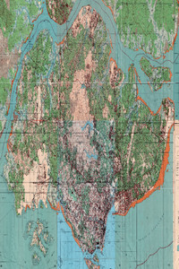
Singapore Provisional Issue, 1953 (12 Sheets)
![]()
Singapore Provisional Issue, 1953 (12 Sheets)
Metadata
| Collection | Historical Maps of Singapore |
|---|---|
| Author/Creator |
Malaya. Survey Department |
| Title |
Singapore Provisional Issue, 1953 (12 Sheets) |
| Publication Date | 1953 |
| Publisher | Kuala Lumpur: Survey Department Federation of Malaya |
| DOI | |
| Subject |
Singapore -- Maps |
| Page | 12 sheets |
| Language | English |
| Content Type | Map |
| Object Type |
Text |
| Terms of Use |
openAccess |
| Terms of Use Others | No reproduction for commercial purposes. See terms of use on libmaps.nus.edu.sg for details. |
| Repository | NUS Libraries |
| Spatial Coverage |
Singapore |
| Version of work | Sheet 1, First Edition Survey Department Federation of Malaya No.16-1953 |
| Description |
A mosaic of 12 sheets of topographical maps of Singapore:Sheet 1 (Lim Chu Kang): This map shows northwestern Singapore and its coastline along the Johore Strait. The Johore coastline is also shown. Major features and areas shown in this map include Lim Chu Kang, Kranji, Sungei Buloh and Lim Chu Kang Road.Sheet 2 (Sembawang): This map shows the northern region of Singapore, with the coastlines of Singapore Johore along the Johore Strait, together with the state border. Major features and areas shown in the map include North Seletar/South Seletar, Sembawang, Mandai, Kranji, Causeway and Sungei Kranji, Sungei Sembawang, Sungei Simpang Kiri, Sungei Mandai, Sungei Mandai Kechil, Sungei Seletar, Sungei Pang Sua, Sungei Jelutong, Sungei Pasir and Sungei Segar.Sheet 3 (Seletar): This map shows Seletar, the northern region of Singapore. The coastline of Singapore and Johore is shown in this map, together with the state boundary along the Johore Strait. Major features include Sungei Seletar, Sungei Punggol, Sungei Simpang and Sungei Khatib Bongsu. Areas shown in the map include Bunggol, South Seletar, North Seletar, Teban, Ang Mo Kio and Sembawang.Sheet 4 (Changi): The map covers north-eastern and eastern Singapore, showing the Singapore and Johore coastline along the Straits of Singapore, Serangoon Harbour and the Johore Straits, together with the state boundary. The islands Pulau Ubin, Pulau Serangoon, Pulau Ketam and Pulau Sekudu are also shown in the map. Some features on the map include Tampines, Punggol, Bedok, Tampines Road, Changi Road, Changi Village, then proposed Paya Lebar international airport under construction.Sheet 5 (Pulau Tekong):This map shows the island of Pulau Tekong that lies northeast to mainland Singapore, along with its surrounding islands. Part of the Johore coastline is also shown, together with the state boundary along the Johore Strait.Sheet 6 (Jurong): This map shows western Singapore, covering the regions such as Peng Kang, Tuas, Bajau, Kranji, Lim Chu Kang and Choa Chu Kang. The coastline is also shown in the map, together with the state boundary in the Johore Strait and islands P.Samulun, P. Merlimau, P. Damar Laut. Waterbodies displayed include Selat Sembilan, Sungei Jurong, Selat Pulau Damar and Sungei Tengeh.Sheet 7 (Bukit Timah): This map covers areas of Bukit Timah, Ulu Pandan, Choa Chu Kang, Bukit Gombak, Ulu Pandan, Bukit Panjang Village, Upper Mandai, Jurong, Kranji, Mandai, Sembawang, Ulu kallang, Bt Brown, Upper Thomson, Toa Payoh and Telok Blanga. Sungei Pandan is shown in the map as well. Major features include the Bukit Timah Nature Reserve, MacRitchie Reservoir, Dunearn Road and Bukit Timah Road.Sheet 8 (Singapore City): This map covers the Singapore City area, including areas such as Paya Lebar, Toa Payoh, Orchard, Balestier, Kg Bugis, Kg Potong Pasir, Geylang, Ang Mo Kio, Thomson, Serangoon, Yio Chu Kang, Saranggong and Kalang. Various rivers are also shown, such as the Kalang River, Sungei Whompoe and Geylang River.Sheet 9 (Siglap): This map covers the southeastern part of Singapore, including parts of Siglap, Chai Chee, Somapah Changi Village, Kg Padang Terbakar, Kg Ayer Gemuruh, Mata Ikan Village, Tg Meng Kwang, Bedok Village, Bedok, Ulu Bedok, Changi. The coastline is also shown in the map.Sheet 10 (Southern Province Islands): This map covers the southwestern islands of Singapore, including islands Pulau Ayer Chawan, Pulau Ayer Merbau, Pulau Pesek, Pulau Merlimau, Pulau Buaya, Pulau Mesemut Laut, Pulau Mesemut Darat, Pulau Meskol, Pulau Seraya, Pulau Seburus Dalam, Pulau Seburus Luar, Pulau Sakra, Pulau Bakau, Pulau Busing, Pulau Ular, Pulau Bukum, Pulau Bukum Kechil, Pulau Hantu and Selat Pandan.Sheet 11: The map shows the city area of Pasir Panjang and Telok Blangah mukim which consist of Henderson, Alexandra, Shenton Way, Ayer Rajah and Tiong Bahru . The southern coastline is shown in the map, along with islands Pulau Subar Darat, Pulau Subar Laut, Pulau Sakijang, Pulau Sakijang Pelepah, Pulau Tembakul, Pulau Seringat/Pulau Rengat, Pulau Tembakul, Pulau Terkukor/Pulau Penyabong, Pulau Blakang Mati, Pulau Selegu, Pulau Renggis, Pulau Brani, Pulau Hantu.Sheet 12: This map displays most of the Southern Islands of Singapore, including islands such as Pulau Senang, Pulau Biola, Pulau Satumu, Pulau Pawai, Pulau Berkas, Pulau Sudong, Pulau Salu, Pulau Semakau, Pulau Sakeng, Pulau Sebarok, Pulau Jong, Pulau Senang, Pulau Biola, Pulau Satumu, Pulau Berkas, Pulau Semakau and Pulau Sakeng. The map also shows the state boundary of Singapore, and the various Straits between the islands.The maps were produced by the Surveyor General, Malaya, scanned by Sakinah Yusof, Department of Geography, National University of Singapore (NUS), georeferenced by Leon Gaw Yan Feng, and mosaicked by NUS Libraries, with kind permission from Singapore Land Authority and Ministry of Defence for NUS Libraries to provide viewing of the map service over the internet. Enlarged version of the map is available online: https://libmaps.nus.edu.sg. |
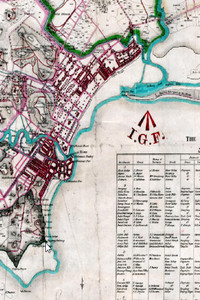
Singapore Residency, 1860
![]()
Singapore Residency, 1860
Metadata
| Collection | Historical Maps of Singapore |
|---|---|
| Author/Creator |
Moniot, Jules M. |
| Title |
Singapore Residency, 1860 |
| Publication Date | 1860 |
| Publisher | London: Smith Elder and Co |
| DOI | |
| Subject |
Singapore -- Maps |
| Page | 1 sheet |
| Language | English |
| Content Type | Map |
| Object Type |
Text |
| Terms of Use |
openAccess |
| Terms of Use Others | Enlarged version of the map is available online: https://libmaps.nus.edu.sg. |
| Repository | NUS Libraries |
| Spatial Coverage |
Singapore |
| Description |
Map showing environs of the City with "A Stranger's Guide to the environs of Singapore", listing Residences, Owners, Occupiers, Roads, Districts and Lot Numbers, etc. A map by J. Moniot, Surveyor General, SS. From War Office and predecessors: Maps and Plans. Straits Settlements: SingaporeThis map was scanned by Sakinah Yusof, Department of Geography, National University of Singapore, and georeferenced by Leon Gaw Yan Feng. |
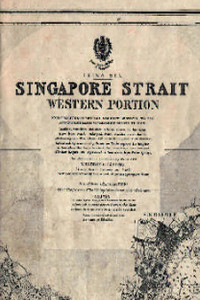
Singapore Strait: Western Portion, 1930 (Scale 1:50,000)
![]()
Singapore Strait: Western Portion, 1930 (Scale 1:50,000)
Metadata
| Collection | Historical Maps of Singapore |
|---|---|
| Author/Creator |
Douglas, H. P. |
| Title |
Singapore Strait: Western Portion, 1930 (Scale 1:50,000) |
| Publication Date | 1930 |
| Publisher | London: Admiralty |
| DOI | |
| Subject |
Singapore -- Maps |
| Page | 1 sheet |
| Language | English |
| Content Type | Map |
| Object Type |
Text |
| Terms of Use |
openAccess |
| Terms of Use Others | Enlarged version of the map is available online: https://libmaps.nus.edu.sg. |
| Repository | NUS Libraries |
| Spatial Coverage |
Singapore |
| Description |
Singapore sea chart published in 1930. Principally from British Admiralty surveys to 1928 and Netherlands Government charts to 1929This map was produced by the British Admiralty, scanned by Sakinah Yusof, Department of Geography, National University of Singapore, and georeferenced by Leon Gaw Yan Feng. |
Singapore West, 2005 (Scale: 1:25,000)
![]()
Singapore West, 2005 (Scale: 1:25,000)
Metadata
| Collection | Historical Maps of Singapore |
|---|---|
| Author/Creator |
Singapore. Ministry of Defence. Mapping Unit |
| Title |
Singapore West, 2005 (Scale: 1:25,000) |
| Publication Date | 2005 |
| Publisher | Singapore: Mapping Unit, Ministry of Defence |
| DOI | |
| Subject |
Singapore -- Maps |
| Page | 6 sheets |
| Language | English |
| Content Type | Map |
| Object Type |
Text |
| Terms of Use |
openAccess |
| Terms of Use Others | No reproduction for commercial purposes. See terms of use on libmaps.nus.edu.sg for details. |
| Repository | NUS Libraries |
| Spatial Coverage |
Singapore |
| Version of work | L 7022 Edition 7B SMU |
| Description |
A mosaic of 6 sheets of topographical maps of Singapore:Sheet 1 (Lim Chu Kang): This map shows the northwestern region of Singapore and the coastline along Straits of Johore, with the state boundary included. Major regions and features in the map include Ama Keng, Lim Chu Kang, Chua Chu Kang, Kranji Reservoir, Mandai, Woodlands, Upper Seletar Reservoir, Upper Pierce Reservoir, Upper Bukit Timah, Jurong West and Jurong East. Also shows the restricted Live Firing Area for Military training.Sheet 2 (Tampines): This map shows the northeast region of Singapore, its coastline and state boundary along the Straits of Johore, Pulau Ubin and its surrounding islands (Pulau Ketam, Pulau Sekudu, Coney Island,Pulau Punggol Timur and Pulau Punggol Barat). Johore and its coastline is shown in the map as well. Major regions and features in the map include Punggol, Sembawang, Lower Seletar Reservoir, Lower Pierce Reservoir, MacRitchie Reservoir, Sin Ming, Ang Mo Kio, Paya Lebar, Sengkang, Punggol, Hougang, Bishan, Yishun, Tampines, Pasir Ris, Changi Airport , Changi, Loyang and Serangoon.Sheet 3 (Pulau Tekong): This map shows the island of Pulau Tekong and its surrounding islands Pulau Sajahat and Pulau Sajahat Kechil, Pulau Semechek, Pulau Unum and Pulau Damien that lies northeast to mainland Singapore. The coastline of Johore and Pulau Tekong are shown in this map, along with major waterways of the Straits of Johore, Straits of Singapore and the state boundary. Major toppgraphical features of Pulau Tekong are displayed in the map, such as Pulau Tekong Reservoir and various estates.Sheet 4 (Jurong): The map shows the south-western region of Singapore . The south-western coastline of Singapore is shown in this map, with the major waterways of Selat Jurong, Selat Pandan, Selat Pesek, Selat Sakra, Selat Bukom, Selat Salu and Selat Samulun as shown. Major islands displayed in the map include Jurong Island, Pulau Bukom and other smaller islands. Major features and regions displayed in this map include Jurong Industrial Estate, Chua Chu Kang, Upper Jurong Road, Jurong Town, Taman Jurong, Tuas, Teban Garden, Pandan Reservoir, Pasir Panjang, Queenstown, Clementi and Bukit Timah.Sheet 5 (Bedok): The map shows the south-eastern region of Singapore. The south-eastern coast line of Singapore fronting the Straits of Singapore is shown as well. Major regions and features in the map include the Changi Business Park, Singapore Changi Airport, MRT Lines, Bedok Police Division HQ, Bedok Industrial Park, Paya Ubi Industrial Park, Tai Seng Industrial Park, Defu Industrial Estate, UBI Technolink, Kaki Bukit TechPark and Industrial Park, Eunos Industrial Estate, Kg Ubi Industrial Estate, along with residential estates like Old kallang Airport estate, Marine Parade, Siglap, Tanah Merah, Bedok, East Coast Park, Changi and Tanah Merah. An inset of Pedra Branca is included.Sheet 7 (Southern Islands): This map shows the Southern Islands of Singapore, together with the state boundary with Indonesia demarcated. Major islands shown in the map include Pulau Semakau, Pulau Sebarok, Pulau Sakeng and the off-limit Live Firing Area of Pulau Sudong, Pulau Pawai Pulau Berkas, Pulau Biola and Pulau Senang in the Straits of Singapore.The maps were produced by the Mapping Unit, Ministry of Defence, Singapore, scanned, georeferenced by Department of Geography, National University of Singapore (NUS) and mosaicked by NUS Libraries, with kind permission from Singapore Land Authority and Ministry of Defence for NUS Libraries to provide viewing of the map service over the internet. |
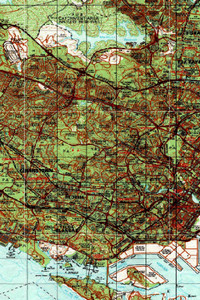
Singapore West, 2010 (Scale: 1:50,000)
![]()
Singapore West, 2010 (Scale: 1:50,000)
Metadata
| Collection | Historical Maps of Singapore |
|---|---|
| Author/Creator |
Singapore. Ministry of Defence. Mapping Unit |
| Title |
Singapore West, 2010 (Scale: 1:50,000) |
| Publication Date | 2010 |
| Publisher | Singapore: Mapping Unit, Ministry of Defence |
| DOI | |
| Subject |
Singapore -- Maps |
| Page | 1 sheet |
| Language | English |
| Content Type | Map |
| Object Type |
Text |
| Terms of Use |
openAccess |
| Terms of Use Others | No reproduction for commercial purposes. See terms of use on libmaps.nus.edu.sg for details. |
| Repository | NUS Libraries |
| Spatial Coverage |
Singapore |
| Version of work | SMU 075 Edition 9 |
| Description |
This map shows the entire Singapore with detail on networks of roads and railways, international boundaries, water features, relief, buildings and vegetation. The coastline of Johor along the Straits of Johor is also shown. Pedra Branca and Pulau Tekong are shown in insets.Central Region: Bishan, Bukit Merah, Bukit Timah, Novena, Potong Pasir, Queenstown, Tanglin, Tiong Bahru, Toa Payoh, Southern Islands, Bras Basah, Chinatown, Downtown Core, Marina Bay, Marina Centre, Marina East, Marina South, Newton, Orchard, Outram, Raffles Place, River Valley, Rochor, Tanjong Pagar.East Region: Bedok, Changi, Changi Bay, Changi East, Changi Village, Geylang, Kallang, Kallang Bahru, Katong, Marine Parade, Paya Lebar, Pasir Ris, Siglap, Tampines, Tampines North, Ubi.North Region: Central Water Catchment, Lim Chu Kang, Mandai, Sembawang, Simpang, Sungei Kadut, Woodlands, Yishun.North-East Region: Ang Mo Kio, Hougang, North-eastern Islands, Punggol, Seletar, Sengkang, Senoko, Serangoon, Serangoon Gardens, Serangoon North.West Region: Bukit Batok, Bukit Panjang, Boon Lay, Bulim, Choa, Chu Kang, Clementi, Joo Koon, Jurong East, Jurong West, Tengah, Tuas, Tuas South, Western Islands, Western Water CatchmentThe maps were produced by the Mapping Unit, Ministry of Defence, Singapore, scanned and georeferenced by Department of Geography, National University of Singapore (NUS), with kind permission from Singapore Land Authority and Ministry of Defence for NUS Libraries to provide viewing of the map service over the internet. |
Singapore, 1862
![]()
Singapore, 1862
Metadata
| Collection | Historical Maps of Singapore |
|---|---|
| Title |
Singapore, 1862 |
| Publication Date | 1862 |
| Publisher | Jules M. Moniot |
| DOI | |
| Subject |
Singapore -- Maps |
| Page | 1 sheet |
| Language | English |
| Content Type | Map |
| Object Type |
Text |
| Terms of Use |
openAccess |
| Terms of Use Others | Enlarged version of the map is available online: https://libmaps.nus.edu.sg |
| Repository | NUS Libraries |
| Spatial Coverage |
Singapore |
| Description |
This map shows south-eastern/central part of Singapore with detailed proposal on roads, water features, government buildings (Temporary Artellary Barrack, Central Police Station, Telegraph Station, Arsenal, Temporary Police Office, Venus Bridge & more..) It also shows proposed site for Kallang Gaswork.This map was scanned by Sakinah Yusof, Department of Geography, National University of Singapore, and georeferenced by Low Taoyang Isaac. |
Loading more items please wait...
All items are loaded.
Error loading more items. Please reload the page an try again.