- Collections
- Historical Maps of Singapore
Title
Year
Author
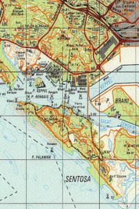
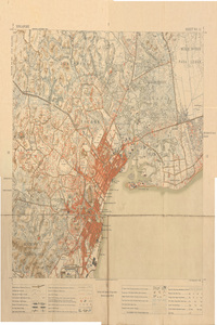
Singapore, 1998 (Scale: 1:50,000)
![]()
Singapore, 1998 (Scale: 1:50,000)
Metadata
| Collection | Historical Maps of Singapore |
|---|---|
| Author/Creator |
Singapore. Ministry of Defence. Mapping Unit |
| Title |
Singapore, 1998 (Scale: 1:50,000) |
| Publication Date | 1998 |
| Publisher | Singapore: Mapping Unit, Ministry of Defence |
| DOI | |
| Subject |
Singapore -- Maps |
| Page | 1 sheet |
| Language | English |
| Content Type | Map |
| Object Type |
Text |
| Terms of Use |
openAccess |
| Terms of Use Others | No reproduction for commercial purposes. See terms of use on libmaps.nus.edu.sg for details. |
| Repository | NUS Libraries |
| Spatial Coverage |
Singapore |
| Version of work | SMU 075 Edition 6 |
| Description |
This map shows Singapore with detail on networks of roads and railways, international boundaries, water features, relief, buildings and vegetation. The coastline of Johor along the Straits of Johor is also shown.Central Region: Bishan, Bukit Merah, Bukit Timah, Novena, Potong Pasir, Queenstown, Tanglin, Tiong Bahru, Toa Payoh, Southern Islands, Bras Basah, Chinatown, Downtown Core, Marina Bay, Marina Centre, Marina East, Marina South, Newton, Orchard, Outram, Raffles Place, River Valley, Rochor, Tanjong Pagar.East Region: Bedok, Changi, Changi Bay, Changi East, Changi Village, Geylang, Kallang, Kallang Bahru, Katong, Marine Parade, Paya Lebar, Pasir Ris, Siglap, Tampines, Tampines North, Ubi.North Region: Central Water Catchment, Lim Chu Kang, Mandai, Sembawang, Simpang, Sungei Kadut, Woodlands, Yishun.North-East Region: Ang Mo Kio, Hougang, North-eastern Islands, Punggol, Seletar, Sengkang, Serangoon.West Region: Bukit Batok, Bukit Panjang, Boon Lay, Bulim, Choa, Chu Kang, Clementi, Joo Koon, Jurong East, Jurong West, Tengah, Tuas, Tuas South, Western Islands, Western Water CatchmentThis map was produced by the Mapping Unit, Ministry of Defence, Singapore, scanned by Sakinah Yusof, Department of Geography, National University of Singapore (NUS), and georeferenced by Leon Gaw Yan Feng, with kind permission from Singapore Land Authority and Ministry of Defence for NUS Libraries to provide viewing of the map service over the internet. |
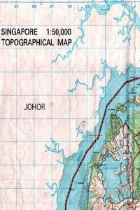
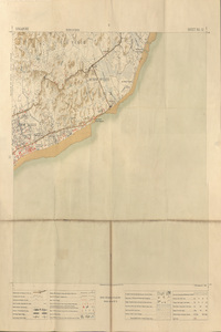
Singapore, 2002 (Scale: 1:50,000)
![]()
Singapore, 2002 (Scale: 1:50,000)
Metadata
| Collection | Historical Maps of Singapore |
|---|---|
| Author/Creator |
Singapore. Ministry of Defence. Mapping Unit |
| Title |
Singapore, 2002 (Scale: 1:50,000) |
| Publication Date | 2002 |
| Publisher | Singapore: Mapping Unit, Ministry of Defence |
| DOI | |
| Subject |
Singapore -- Maps |
| Page | 1 sheet |
| Language | English |
| Content Type | Map |
| Object Type |
Text |
| Terms of Use |
openAccess |
| Terms of Use Others | No reproduction for commercial purposes. See terms of use on libmaps.nus.edu.sg for details. |
| Repository | NUS Libraries |
| Spatial Coverage |
Singapore |
| Version of work | SMU 075 Edition 7 |
| Description |
This map shows Singapore with detail on networks of roads and railways, international boundaries, water features, relief, buildings and vegetation. The coastline of Johor along the Straits of Johor is also shown. Pulau Tekong is shown in an inset.This map was produced by the Mapping Unit, Ministry of Defence, Singapore, scanned by Sakinah Yusof, Department of Geography, National University of Singapore (NUS), and georeferenced by Leon Gaw Yan Feng, with kind permission from Singapore Land Authority and Ministry of Defence for NUS Libraries to provide viewing of the map service over the internet. |
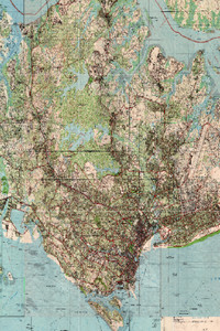
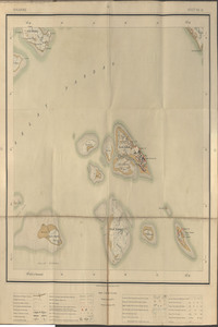
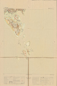
Singapore: Ama Keng, Nee Soon, Changi, Pulau Tekong, Jurong, City, Siglap, 1975 (Scale: 1:25,000)
![]()
Singapore: Ama Keng, Nee Soon, Changi, Pulau Tekong, Jurong, City, Siglap, 1975 (Scale: 1:25,000)
1975
Singapore. Ministry of Defence. Mapping Unit
Metadata
| Collection | Historical Maps of Singapore |
|---|---|
| Author/Creator |
Singapore. Ministry of Defence. Mapping Unit |
| Title |
Singapore: Ama Keng, Nee Soon, Changi, Pulau Tekong, Jurong, City, Siglap, 1975 (Scale: 1:25,000) |
| Publication Date | 1975 |
| Publisher | Singapore: Mapping Unit, Ministry of Defence |
| DOI | |
| Subject |
Singapore -- Maps |
| Page | 8 sheets |
| Language | English |
| Content Type | Map |
| Object Type |
Text |
| Terms of Use |
openAccess |
| Terms of Use Others | No reproduction for commercial purposes. See terms of use on libmaps.nus.edu.sg for details. |
| Repository | NUS Libraries |
| Spatial Coverage |
Singapore |
| Version of work | SMU 025 Edition 1 SMU |
| Description |
A mosaic of 8 sheets of topographical maps of Singapore:Sheet 1 (Ama Keng): This map shows the northwestern region of Singapore and the coastline along Straits of Johore, with the state boundary included. Major regions and features in the map include Ama Keng, Lim Chu Kang Road, Kranji Reservoir, Sungei Poyan, Sungei Berih, Sungei Karang, Sungei Kangkar, Sungei Buloh, Sungei Kranji, Sungei Peng Siang, Sarimbun in Singapore and Pelentong, Sungei Sekudai, Sungei Pendas, Sungei Perepat, Sungei Danga, Sungei Melayu in Johore Bahru.Sheet 2 (Nee Soon): The map shows the Northern region of Singapore, with the Singapore and Johore coastline along the Straits of Johore, together with the state boundary. Major features include Woodlands, Sembawang, Kranji, Admiralty, Marsiling, Bukit Panjang, Seletar Reservoir, Bukit Timah Nature Reserve, Pulau Seletar, Yio Chu Kang, Johore, Sembawang Shipyard and the Causeway Bridge.Sheet 3 (Changi): This map shows the northeast region of Singapore, its coastline along the Straits of Johore, Pulau Ubin, Pulau Sekudu, Pulau Ketam, Pulau Serangoon (Coney Island) and surrounding islands. Johore and its coastline is shown in the map as well. Major regions and features in the map include Changi, Loyang, Pasir Ris, Serangoon, Punggol, Jalan Kayu and Sembawang of mainland Singapore, Sungei Tiram and various estates of Johore Bahru.Sheet 4 (Pulau Tekong): This map shows the island of Pulau Tekong and its surrounding islands that lies northeast to mainland Singapore. The coastline and features of Johore and Pulau Tekong are shown in this map, along with major waterways of the Straits of Johore, Johore River and the state boundary. Major topographical features of Johore are shown in the map, including regions such as Kota Tinggi.Sheet 5 (Jurong): The map shows the south-western region of Singapore in 1975. The south-western coastline of Singapore is shown in this map, with the major waterways of Selat Johore, Selat Sembilan and Selat Pandan shown. Major islands displayed in the map include Pulau Sakra, Pulau Bakau, Pulau Ayer Merbau, Pulau Ayer Chawan, Pulau Seraya, Pulau Merlimau, Pulau Pesek, Pulau Mesemut Laut, Pulau Mesemut Darat, Pulau Meskol, Pulau Seburus Dalam, Pulau Seburus Luar Pulau Damar Laut and amongst other smaller islands. Major features and regions displayed in this map include Jurong Industrial Estate, Pioneer Road, Jln Ahmad Ibrahim, Jalan Buroh, Corporation Road, Upper Jurong Road, Tuas, Lokyang, Hong Kah, Kampong Ulu Pandan, Pandan Nature Reserve, Pandan Reservoir and Choa Chu Kang.Sheet 6 (Singapore City): The map shows the southern-central region of Singapore in 1975. The map shows the southern-central region of Singapore. The southern coastline of Singapore is shown, along with islands such as Pulau Blakang Mati, Pulau Hantu, Pulau Bukum and Pulau Brani. Waterways shown include Keppel Harbour and Selat Sengkir, Kallang River, Singapore River, Sungei Pandan. Major regions in the map include Singapore City, Thomson, Ang Mo Kio, Toa Payoh, Potong Pasir, Bukit Timah, Bukit Panjang, Pierce Reservoir, Clementi, Alexandra, Kent Ridge, Jurong, Queenstown and Bukit Gombak, Mount Faber.Sheet 7 (Siglap): The map shows the south-eastern region of Singapore in 1975. The south-eastern coast line of Singapore fronting the Straits of Singapore is shown as well. Major regions and features in the map include Kallang, Geylang, Serangoon, Bartley, Paya Lebar, Mountbatten, Tg Katong, Tg Rhu, Katong, Meyer Road, Siglap, Frankel, Fidelio Street, Eunos, Kembangan, Ubi, Marine Parade, Paya Lebar Airport, Tampines, Pasir Ris, Changi, Bedok, East Coast Park and Tanah Merah.Sheet 8 (Southern Islands): This map shows the Southern Islands of Singapore, together with the state boundary demarcated. Major islands shown in the map include Sentosa, Pulau Semakau, Lazarus Island, St. John Island, Pulau Bukum, Pulau Anak Bukom, Pulau Hantu, Pulau Ular, Pulau Jong, Pulau Salu, Pulau Sudong, Pulau Pawai, Pulau Senang, Pulau Biola, Pulau Satumu, Pulau Sakeng, Pulau Sebarok, Pulau Terkukor, Pulau Sakijang Bendera, Pulau Sakijang Pelepah, Pulau Seringat, Pulau Subar Laut, Pulau Subar Darat, Pulau Tembakul and other smaller islands.The maps were produced by the Mapping Unit, Ministry of Defence, Singapore, scanned by Sakinah Yusof, Department of Geography, National University of Singapore (NUS), and georeferenced by Leon Gaw Yan Feng, with kind permission from Singapore Land Authority and Ministry of Defence for NUS Libraries to provide viewing of the map service over the internet. |

Singapore. Sheet No. 10 (Scale approximately 1:42,240)
![]()
Singapore. Sheet No. 10 (Scale approximately 1:42,240)
1924
Malay States, Federated. Survey Dept.
Straits Settlements. Survey Dept.
Metadata
| Collection | Historical Maps of Singapore |
|---|---|
| Author/Creator |
Malay States, Federated. Survey Dept. Straits Settlements. Survey Dept. |
| Title |
Singapore. Sheet No. 10 (Scale approximately 1:42,240) |
| Publication Date | 1924 |
| Publisher | Singapore: Published under the direction of the Surveyor General, F.M.S. & S.S |
| DOI | |
| Call Number | DS598 Sin.M |
| Subject |
Singapore -- Maps |
| Page | 1 sheet |
| Language | English |
| Content Type | Map |
| Object Type |
Text |
| Terms of Use |
openAccess |
| Terms of Use Others | No reproduction for commercial purposes. See terms of use on libmaps.nus.edu.sg for details. |
| Repository | NUS Libraries |
| Spatial Coverage |
Singapore |
| Series | F.M.S. surveys : No 7 |
| Description |
Map of Singapore showing districts Mukim boundary and numbers |
Singapore. Sheet No. 11 (Scale approximately 1:42,240)
![]()
Singapore. Sheet No. 11 (Scale approximately 1:42,240)
1924
Malay States, Federated. Survey Dept.
Straits Settlements. Survey Dept.
Metadata
| Collection | Historical Maps of Singapore |
|---|---|
| Author/Creator |
Malay States, Federated. Survey Dept. Straits Settlements. Survey Dept. |
| Title |
Singapore. Sheet No. 11 (Scale approximately 1:42,240) |
| Publication Date | 1924 |
| Publisher | Singapore: Published under the direction of the Surveyor General, F.M.S. & S.S |
| DOI | |
| Call Number | DS598 Sin.M |
| Subject |
Singapore -- Maps |
| Page | 1 sheet |
| Language | English |
| Content Type | Map |
| Object Type |
Text |
| Terms of Use |
openAccess |
| Terms of Use Others | No reproduction for commercial purposes. See terms of use on libmaps.nus.edu.sg for details. |
| Repository | NUS Libraries |
| Spatial Coverage |
Singapore |
| Series | F.M.S. surveys : No 7 |
| Description |
Map of Singapore showing districts Mukim boundary and numbers |
Singapore. Sheet No. 12 (Scale approximately 1:42,240))
![]()
Singapore. Sheet No. 12 (Scale approximately 1:42,240))
1924
Malay States, Federated. Survey Dept.
Straits Settlements. Survey Dept.
Metadata
| Collection | Historical Maps of Singapore |
|---|---|
| Author/Creator |
Malay States, Federated. Survey Dept. Straits Settlements. Survey Dept. |
| Title |
Singapore. Sheet No. 12 (Scale approximately 1:42,240)) |
| Publication Date | 1924 |
| Publisher | Singapore: Published under the direction of the Surveyor General, F.M.S. & S.S |
| DOI | |
| Call Number | DS598 Sin.M |
| Subject |
Singapore -- Maps |
| Page | 1 sheet |
| Language | English |
| Content Type | Map |
| Object Type |
Text |
| Terms of Use |
openAccess |
| Terms of Use Others | No reproduction for commercial purposes. See terms of use on libmaps.nus.edu.sg for details. |
| Repository | NUS Libraries |
| Spatial Coverage |
Singapore |
| Series | F.M.S. surveys : No 7 |
| Description |
Map of Singapore showing districts Mukim boundary and numbers |
Singapore. Sheet No. 14 (Scale approximately 1:42,240)
![]()
Singapore. Sheet No. 14 (Scale approximately 1:42,240)
1924
Malay States, Federated. Survey Dept.
Straits Settlements. Survey Dept.
Metadata
| Collection | Historical Maps of Singapore |
|---|---|
| Author/Creator |
Malay States, Federated. Survey Dept. Straits Settlements. Survey Dept. |
| Title |
Singapore. Sheet No. 14 (Scale approximately 1:42,240) |
| Publication Date | 1924 |
| Publisher | Singapore: Published under the direction of the Surveyor General, F.M.S. & S.S |
| DOI | |
| Call Number | DS598 Sin.M |
| Subject |
Singapore -- Maps |
| Page | 1 sheet |
| Language | English |
| Content Type | Map |
| Object Type |
Text |
| Terms of Use |
openAccess |
| Terms of Use Others | No reproduction for commercial purposes. See terms of use on libmaps.nus.edu.sg for details. |
| Repository | NUS Libraries |
| Spatial Coverage |
Singapore |
| Series | F.M.S. surveys : No 7 |
| Description |
Map of Singapore showing districts Mukim boundary and numbers |
Singapore. Sheet No. 15 (Scale approximately 1:42,240)
![]()
Singapore. Sheet No. 15 (Scale approximately 1:42,240)
1924
Malay States, Federated. Survey Dept.
Straits Settlements. Survey Dept.
Metadata
| Collection | Historical Maps of Singapore |
|---|---|
| Author/Creator |
Malay States, Federated. Survey Dept. Straits Settlements. Survey Dept. |
| Title |
Singapore. Sheet No. 15 (Scale approximately 1:42,240) |
| Publication Date | 1924 |
| Publisher | Singapore: Published under the direction of the Surveyor General, F.M.S. & S.S |
| DOI | |
| Call Number | DS598 Sin.M |
| Subject |
Singapore -- Maps |
| Page | 1 sheet |
| Language | English |
| Content Type | Map |
| Object Type |
Text |
| Terms of Use |
openAccess |
| Terms of Use Others | No reproduction for commercial purposes. See terms of use on libmaps.nus.edu.sg for details. |
| Repository | NUS Libraries |
| Spatial Coverage |
Singapore |
| Series | F.M.S. surveys : No 7 |
| Description |
Map of Singapore showing districts Mukim boundary and numbers |
Loading more items please wait...
All items are loaded.
Error loading more items. Please reload the page an try again.